

In brief
Remote sites need connectivity designed around their location, applications and operating conditions. Heavy rain or an obstructed view of the sky can weaken a satellite path, while local power cuts can disrupt nearby mobile infrastructure.
CSL Outpost brings up to four active mobile connections together as one managed link, using appropriately positioned antennas indoors and/or outdoors to make the most of the mobile coverage available at the site. Satellite and fixed-line paths can also be incorporated where they add useful bandwidth or resilience. CSL can therefore design the combination around the site’s coverage, applications and continuity requirements rather than relying on a single route or access technology.
An operations team monitoring CCTV at a remote substation, for example, needs video to remain available when one path is degraded or unavailable. Because satellite and mobile paths have different dependencies, an available alternative can continue carrying the site’s traffic when another path is impaired.
Satellite and mobile paths have different dependencies
Satellite broadband services use satellites in low Earth orbit (LEO), at altitudes up to about 2,000 km, or in geostationary orbit (GEO), about 36,000 km above the equator. Both types require a suitable view of the sky, power at the site and an operational satellite network and ground infrastructure. A mobile connection also needs power at the site, and depends on nearby masts with power and on a working mobile core.
Resilient site connectivity depends on how well the available connections complement one another. Satellite and mobile paths respond differently to weather, obstructions and infrastructure faults, so combining them can help maintain service when one path is affected. The table below shows these differences and how CSL Outpost can distribute traffic across the paths that remain available.
How different conditions affect satellite and mobile connections
Scroll the table sideways on a small screen.
| Condition | Satellite (LEO and GEO) | Mobile (4G and 5G) | How CSL Outpost uses the available paths |
|---|---|---|---|
| Heavy rain | Slows the link about 4 dB of rain loss on a 26-degree path at a representative rainfall rate of 20 mm/h (every 10 dB is a tenfold reduction in received power) |
Little effect under 0.1 dB over 5 km of the same rain |
Redistributes traffic across the available mobile connections |
| Trees or a blocked sky | Needs a sufficiently clear view of the sky trees in leaf block more of the signal than bare branches |
No view of the sky needed | Redistributes traffic across the available mobile connections |
| Antenna location: indoors or outdoors | The antenna must be outdoors building entry would remove about 31 dB in a traditional building and 48 dB in a thermally efficient one at 12 GHz from a satellite at 60 degrees (23 to 40 dB on a 26-degree GEO path) |
Supports indoor installation, with antenna positioning tailored to the site. Building entry removes about 15 dB in a traditional building and 31 dB in a thermally efficient one, at 2 to 3.5 GHz. | Supports external mobile antennas where the site assessment identifies a benefit |
| Storm-force wind | Acts on the exposed mount | Mobile antennas can be positioned to balance reception and exposure at the site. | Redistributes traffic across the connections that remain available |
| Power cut at local masts | No local mast in the path | Masts need mains power | Carries the traffic on satellite, where the satellite equipment has backup power |
| Power cut at the site | Needs backup power at the site | Needs backup power at the site | Its internal battery runs the unit for about 45 minutes A suitably sized UPS can support longer outages and other site equipment |
| Fault in an operator’s core | The satellite path depends on its own service infrastructure | Affects mobile connections that depend on the affected core | Continues using paths whose underlying infrastructure remains available CSL assesses mobile-core independence for each deployment |
CSL uses these differences to select connections with complementary dependencies, reducing the likelihood that the same event will affect every available path. Overall availability also depends on the installation, the underlying network services and the site’s backup-power provision. Losses are CSL calculations from recommendations published by the International Telecommunication Union’s radiocommunication sector (ITU-R): ITU-R P.618, P.838-3, P.833-10 and P.2109-2; building entry figures are medians.
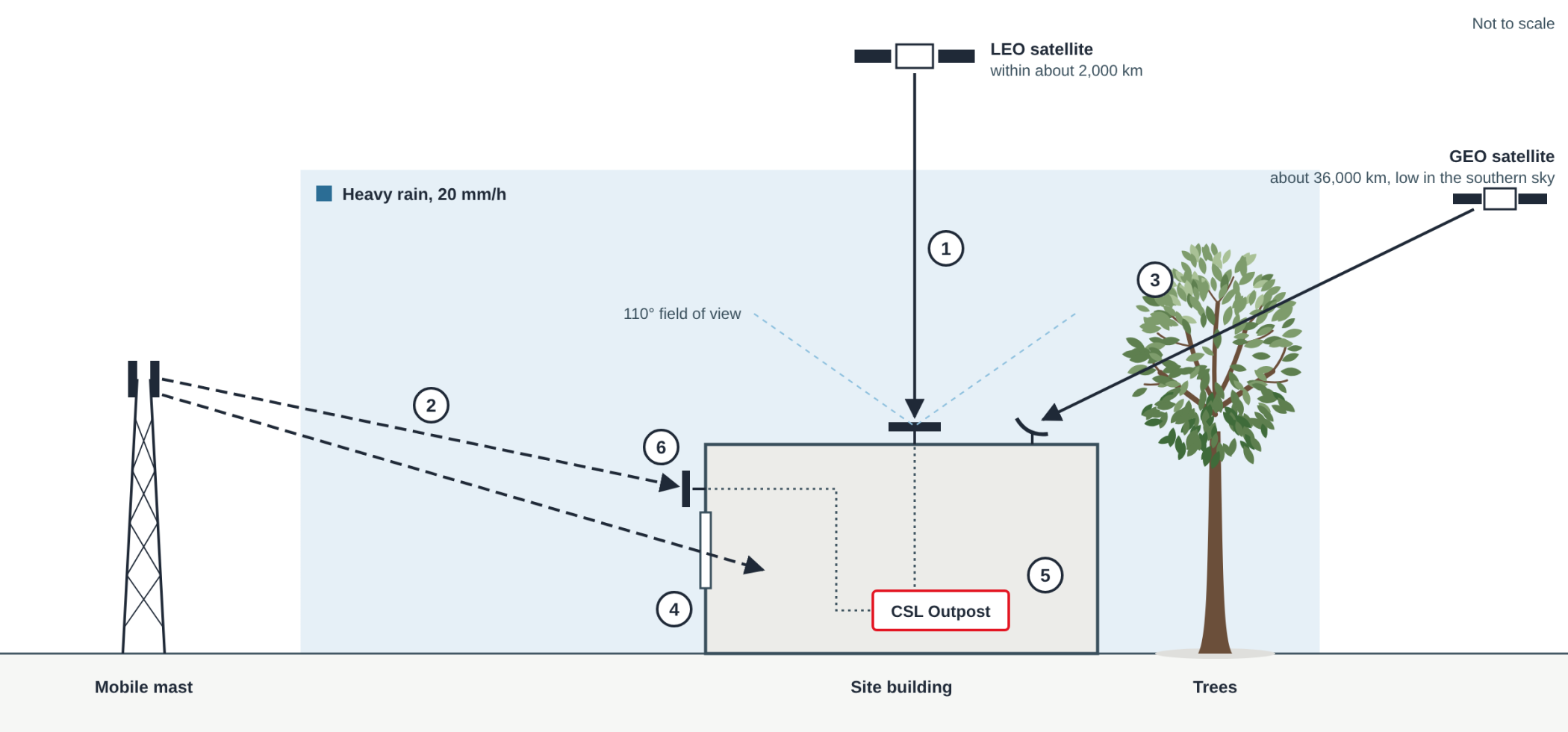
The corresponding side view below shows where each kind of signal loses strength on its way to the same site.
Where satellite and mobile signals lose strength on the way to a site
A side view, not to scale. The numbers mark where each kind of signal is weakened.
Scroll the drawing sideways on a small screen.
|
1
|
Rain on a satellite path: about 4 dB at 12 GHz on a 26-degree path at the 20 mm/h rate, exceeded for 0.01 per cent of the year; 2 to 3 dB on steeper LEO paths |
|
2
|
Rain on a mobile path: under 0.1 dB over 5 km at 2 GHz or 3.5 GHz |
|
3
|
Trees across a low satellite path: about 20 dB for 10 m of woodland at 12 GHz, an illustrative figure |
|
4
|
Building entry, mobile signal: about 15 dB for a traditional building and 31 dB for a thermally efficient one at 2 to 3.5 GHz, both medians |
|
5
|
If a satellite antenna were indoors (not shown): building entry would remove about 31 dB in a traditional building and 48 dB in a thermally efficient one at 12 GHz from a satellite at 60 degrees, illustrating why a suitable outdoor position is required |
|
6
|
External mobile antenna: receives the signal outside the building and connects to CSL Outpost’s mobile antenna ports. |
CSL calculated the figures from ITU-R P.618, P.838-3, P.833-10 and P.2109-2. The drawing shows rain across every path; trees are drawn across the low GEO path. A site normally uses one satellite service; LEO and GEO antennas are drawn together for comparison.
Find out more: CSL Outpost technical information
How site connectivity differs from phone-to-satellite services
Phone-to-satellite services connect compatible handsets directly to satellites. For a site running CCTV or operational monitoring, satellite connectivity is instead provided through a dedicated terminal.
Ofcom set out its decisions on authorising direct-to-device (D2D) services in mobile spectrum bands in a statement on 9 December 2025. Its consultation described how these services could extend outdoor mobile coverage and provide basic backup during terrestrial network outages. That handset-focused role differs from providing connectivity for a site’s installed systems.
Where satellite is required, CSL Outpost bonds the connection from a dedicated satellite terminal with the site’s mobile connections into one managed link, supporting applications such as CCTV and operational monitoring.
Find out more: Ofcom: Enabling satellite direct to device services in mobile spectrum bands

Why rain affects satellite and mobile signals differently
Rain absorbs and scatters the high-frequency signals that satellite links use, which lowers the speed a link can sustain. For example, researchers at TU Berlin measured the performance of a LEO satellite terminal on a university roof for 56 days in 2025. Median download speed in what they called heavy rain was about a fifth lower than in dry hours, although rain was rare during the study. The study’s heaviest rainfall category reached only 4 mm/h, compared with the 20 mm/h rate used in the chart below.
Mobile connections use lower frequencies, so the same rain has far less effect on them. Applying the ITU-R rain-attenuation model shows that a 12 GHz signal is more susceptible to heavy rain than signals at common 4G and 5G frequencies. The modelled attenuation per kilometre is around 100 times that at 3.5 GHz and around 400 times that at 2 GHz in rain of 20 mm/h. These comparisons illustrate the difference between frequencies rather than predicting the performance of a particular service or site.
How much heavy rain weakens each signal
These figures compare how strongly rain affects each signal. Where suitable mobile paths remain available, they can carry more of the site’s traffic when heavy rain reduces the capacity of the satellite path.
Modelled signal loss per kilometre at a rainfall rate of 20 mm/h. In a two-year beacon study at two sites in southern England, the rain rates exceeded for 0.01 per cent of the year were 19.67 and 20.82 mm/h. This exceedance period is equivalent to about 53 minutes annually.
| Satellite 12 GHz, LEO and GEO |
0.7 to 0.8 dB per km |
| 5G mobile 3.5 GHz |
about 0.008 dB per km |
| 4G mobile 2 GHz |
about 0.002 dB per km |
The satellite bar is drawn to scale. At that scale the mobile bars would be too short to see, so they are drawn at a minimum length; the labels give the calculated values.
Over the whole path to a satellite at 26 degrees elevation from southern England, ITU-R P.618 predicts about 4 dB of rain loss at 12 GHz for 0.01 per cent of an average year. That prediction uses a rainfall rate of 20 mm/h, representative of the 19.67 and 20.82 mm/h rates measured at the two southern England sites for 0.01 per cent of the year. With the higher rate from the ITU-R P.837 rain map for the area, about 28 mm/h, the prediction is about 5 dB. CSL calculations from ITU-R P.838-3 and P.618.
A second study, by VTT Technical Research Centre of Finland and the University of Oulu, measured a vehicle-roof satellite terminal during June 2024. During rain of up to 12.5 mm/h, median upload speed fell by about half. The Berlin study found no significant relationship between rain and upload speed. The two studies used different terminals and recorded different rain intensities, so neither upload result describes every site. For upload-dependent applications such as CCTV, CSL therefore works with the customer to assess performance against the application’s requirements and the conditions at the site. Where suitable mobile paths remain available, CSL Outpost can continue carrying traffic across them while the satellite path is degraded.
Find out more:
- Multi-Modal Measurements of Weather Effects and Link Quality Dynamics in LEO Satellite Networks
- Study of weather effects on LEO satellite connectivity
- Recommendation ITU-R P.838-3: Specific attenuation model for rain
- Recommendation ITU-R P.618-14: Propagation data and prediction methods for Earth-space systems

Where to position the satellite and mobile antennas
Satellite and mobile connections have different installation requirements. Understanding these at the survey stage helps identify the right combination of connections and antenna positions for the site.
A dedicated satellite terminal needs a sufficiently clear view of the sky across its required field of view. For a GEO dish at a UK site, this means a clear line of sight towards the geostationary satellite’s position in the southern sky. Nearby trees should be assessed with seasonal changes in mind: a position surveyed in winter may become more obstructed when branches are in leaf.
Mobile connectivity supports indoor installation where sufficient signal strength and quality are available. Building materials, insulation and antenna positioning influence reception, so assessing the intended equipment position helps establish the most suitable installation approach. External antennas provide another option where they would improve reception.
For CSL Outpost, the site assessment includes surveying the available mobile networks using a CSL Signal Analyser or equivalent equipment and identifying a suitable position for any satellite terminal. National coverage maps can inform initial planning, while on-site measurements help establish the reception available at the actual installation position.
Together, these checks help CSL select and position the connections around the site’s applications, bandwidth and continuity requirements.
Find out more:
How storms affect antennas, power and local mobile infrastructure
Severe weather can affect the physical installation as well as the radio path. Satellite antenna specifications can give two wind ratings: an operational rating, covering the conditions in which the antenna can continue working, and a survival rating, covering the conditions it can withstand without permanent damage. Manufacturers do not always publish both ratings, so the available specifications should be checked for an exposed site. During Storm Éowyn on 24 January 2025, for example, the Met Office station at Drumalbin in Lanarkshire recorded a gust of 100 mph.
Storms also cut power: after Storm Arwen in November 2021, about 40,000 customers were without supply for more than three days. Mast sites need mains power too, and the Energy Emergencies Executive Committee’s review of the storm records slow recovery of mobile services. A satellite path does not depend on the local mobile mast and, when supported by suitable backup power and an operational satellite service, can provide an alternative while terrestrial mobile coverage is restored.
CSL Outpost’s internal battery helps bridge short power interruptions, providing around 45 minutes of runtime for the unit. Where longer continuity is required, a suitably sized uninterruptible power supply (UPS) can support CSL Outpost, any satellite terminal and connected equipment. The UPS capacity should be selected around the combined power demand and the runtime the site needs.
Find out more:
Independent mobile-core paths also reduce exposure to a single core failure
CSL Outpost can combine connections across different UK mobile networks to provide greater path diversity. CSL designs each deployment around the underlying network dependencies as well as the available mobile coverage, helping ensure that additional connections provide meaningful diversity rather than increasing the number of SIMs. This means a fault affecting one mobile path does not necessarily affect the others, allowing CSL Outpost to continue using the connections that remain available.
Matching connectivity to the site’s requirements
The right connectivity mix starts with understanding what the site needs to support and the conditions it must withstand. CSL considers five practical questions to shape the appropriate combination of mobile, satellite and fixed-line connections.
Five questions to answer before choosing the connections
|
1
|
What bandwidth does each application require, and what level of service must be maintained if a connection is degraded? |
|
2
|
If satellite connectivity is being considered, does the proposed antenna position have a sufficiently clear view of the sky throughout the year, including when nearby trees are in leaf? |
|
3
|
Where will the equipment be installed, and what is the building made of? |
|
4
|
Which mobile networks reach the site, and do they provide independent mobile-core paths? |
|
5
|
How long must the site stay connected through a power cut? |
These questions provide a starting point for a wider discussion about the site, its applications and its continuity requirements. CSL works with each customer to understand the operational environment and develop the appropriate combination of mobile, satellite and fixed-line connectivity. To discuss the site’s requirements with CSL’s team, contact sales@csl-group.com.
The connectivity challenges CSL Outpost is designed to address
CSL Outpost is particularly suited to sites that:
- support remote or distributed operations in critical infrastructure, utilities or renewable energy
- need connectivity that accounts for the different effects of weather and storms on each path
- require connectivity paths with different dependencies to reduce exposure to a single failure
- need the combined bandwidth of several active connections for applications such as CCTV, video analytics or operational monitoring
- need consistent IP addressing for monitoring platforms and firewall rules as traffic is redistributed across available paths
CSL Outpost is provided as a fully managed service, bringing together connectivity, hardware, installation, 24/7 monitoring and ongoing support.
Choosing the right managed connectivity solution
Different sites require different combinations of bandwidth, resilience and path diversity. CSL DualCore® architecture provides two secure, independent mobile-core paths. A CSL DualSIM® Router configured for core independence delivers that architecture for CCTV and other site equipment.
CSL Outpost is designed for sites that need multiple connections working together as one managed link. At some sites, appropriately positioned external antennas can make mobile connectivity viable where indoor reception would not meet the application’s requirements. CSL Outpost can then combine several active mobile connections to provide the required bandwidth and resilience without satellite. Where mobile connectivity alone cannot meet the site’s requirements, CSL Outpost can also incorporate satellite and fixed-line paths. The appropriate combination depends on the coverage available at the installation position, the applications and their bandwidth requirements, the conditions that could affect each path and the level of continuity the site needs.
CSL provides managed connectivity for critical IoT and safety applications, supporting more than 3.5 million active connections. If you are planning connectivity for a remote or operational site, CSL can assess the applications, bandwidth, coverage, power and failure conditions involved before recommending the appropriate mix of mobile, satellite and fixed-line paths. Contact sales@csl-group.com to discuss the requirements for your site.
Related reading: CSL Outpost: four active mobile connections, managed as one link
Appendix: How the rain figures were calculated
The figures in this article combine measurements from a two-year ALPHASAT beacon study in southern England with calculations based on ITU-R propagation models. The table below records the inputs, methods and results used. It is included to distinguish measured rainfall conditions from CSL’s modelled signal-loss figures.
The P.618 calculations use Chilbolton at 51.14° N, 1.44° W, with a station height of 80 m.
Scroll the table sideways on a small screen.
| Figure as published | Inputs | Method | Result | Source |
|---|---|---|---|---|
| About 20 mm/hrepresentative rain rate | Rain rate exceeded for 0.01 per cent of the time, measured over two years at Chilton (19.67 mm/h) and Chilbolton (20.82 mm/h) | Read from the study and rounded | 19.67 to 20.82 mm/h | Papafragkakis et al. (2019), Table 2 |
| About 53 minutes a year | An exceedance probability of 0.01 per cent over an average year of 365.25 days (525,960 minutes) | 0.0001 × 525,960 minutes | 52.6 minutes | CSL calculation |
| 0.7 to 0.8 dB per kmsatellite, 12 GHz | Rain rate 20 mm/h; horizontal and vertical polarisation | ITU-R P.838-3: specific attenuation k × R raised to the power α, with k and α taken from the coefficient tables for each frequency | 0.707 to 0.824 dB per km | ITU-R P.838-3, equation 1 and coefficient tables |
| About 0.008 dB per km5G mobile, 3.5 GHz | Rain rate 20 mm/h; horizontal and vertical polarisation | ITU-R P.838-3, with the coefficients for this frequency | 0.0071 to 0.0081 dB per km | ITU-R P.838-3 |
| About 0.002 dB per km4G mobile, 2 GHz | Rain rate 20 mm/h; horizontal and vertical polarisation | ITU-R P.838-3, with the coefficients for this frequency | 0.0017 to 0.0021 dB per km | ITU-R P.838-3 |
| Around 100 times12 GHz against 3.5 GHz | Midpoints 0.765 and 0.0076 dB per km | Ratio of the two midpoints | 101 | CSL calculation |
| Around 400 times12 GHz against 2 GHz | Midpoints 0.765 and 0.0019 dB per km | Ratio of the two midpoints | 403 | CSL calculation |
| Under 0.1 dB over 5 km 5G and 4G mobile |
Loss per km at 3.5 GHz and 2 GHz; the same illustrative 5 km distance through rain | Loss per km × 5 | 0.036 to 0.041 dB; 0.009 to 0.010 dB | CSL calculation |
| About 4 dB26-degree path, 12 GHz | Chilbolton, 26 degrees elevation, circular polarisation, representative rain rate of 20 mm/h, rounded from the two measured UK values, loss exceeded for 0.01 per cent of an average year | ITU-R P.618 rain attenuation method, Section 2.2.1.1, run in the itur package | 3.94 dB | ITU-R P.618-13; CSL calculation |
| About 2 to 3 dBsteeper LEO paths, 12 GHz | Chilbolton, 40, 60 and 90 degrees elevation, circular polarisation, representative rain rate of 20 mm/h, loss exceeded for 0.01 per cent of an average year | ITU-R P.618 rain attenuation method, Section 2.2.1.1, run in the itur package | 2.99, 2.37 and 2.13 dB | ITU-R P.618-13; CSL calculation |
| About 5 dB26-degree path, rain-map rate | Chilbolton, 26 degrees elevation, circular polarisation, the ITU-R rain map’s rate for Chilbolton (27.87 mm/h) in place of the representative rate | ITU-R P.618 rain attenuation method, Section 2.2.1.1, run in the itur package | 5.08 dB | ITU-R P.618-13 and P.837-7; CSL calculation |
Calculation note: CSL ran these calculations using the open-source itur package, version 0.4.0, which implements ITU-R P.618-13 and the P.837-7 rain map. P.618-14 and P.837-8 are the editions now in force. The results shown here record the calculations used for this article and have not been recalculated under the later editions. The 5 km rain distance is illustrative. Rainfall inputs are taken from Papafragkakis, Ventouras, Kourogiorgas and Panagopoulos, “ALPHASAT site diversity experiments in Greece and the UK at Ka band: Comparison of 2-years’ results”, ITU Journal: ICT Discoveries, vol. 2, no. 1, 2019.
Where a result derived from ITU-R P.838-3 is shown as a range, it spans the results obtained using horizontal and vertical polarisation coefficients. The calculations are intended to compare frequency sensitivity under the same rainfall conditions, rather than predict a specific deployed link.